
Rockville Centre Neighbors by Block
For a defensible block lookup, start with the least personal record. Nassau GIS shows parcel polygons and the physical features around them. LRV supplies assessment-card context for a matched address or SBL. Clerk maps and land instruments can explain a lot split or a recorded land relationship. The library and local historical collections offer dated address associations. Each source contributes a different fact, and none is a current household roster.
| Rockville Centre block source | What it can show | Access route |
|---|---|---|
| Nassau GIS parcels and lots | Polygon edges, parcel identifiers, address labels, and road, rail, or park context | Online Identify tools and REST service |
| Nassau Land Records Viewer | Parcel card, SBL, roll values, tax context, and Village/Town fields | Address or SBL lookup |
| Nassau historic map layers | 1926 and 1950 county geography and visible road or lot change | GIS layer toggle |
| Nassau Clerk maps and instruments | Recorded subdivision, highway, deed, or map information | Official Land Search or office request |
| RVC Library, NY Heritage, Historical Society | Dated directory, newspaper, map, or house-history association | Digital collections and reference routes; holdings vary |
Call a parcel “adjacent” only when the displayed geometry supports it. A parcel on the same block face, a parcel across a roadway, and one that shares an edge are different relationships. State which one applies and the map date. That simple discipline makes neighbors research clearer and safer.
Define Rockville Centre Parcel Adjacency
“Neighbor” has several meanings. It may mean a parcel sharing an edge, an address across a public road, a nearby lot inside an unstated radius, or a social relationship. Public mapping can reproduce the first two categories. It cannot prove the last two. Before searching, write the defined unit in the research note: shared boundary, same block face, or across-road parcel.
Roads, railroad corridors, parks, water, and rights-of-way should remain visible while the map is read. A road between two polygons means they are near each other across a road, not one combined parcel. If the target is a PO Box, stop. A PO Box identifies a mailing route and cannot produce a residential parcel map.
Map a Rockville Centre Parcel Block
Nassau’s public GIS supplies an address search, Identify tool, parcel geometry, and distance or area functions. The REST service exposes parcel fields including PARCEL, PARCELKEY, PARID, PARCEL_ADDRESS, and ROLL_YEAR, which makes a spatial observation easier to document. The reviewed tools did not show a one-click public radius search that returns neighborhood households.
- Normalize the physical address with USPS, then locate it in the Nassau GIS viewer.
- Use Identify on the target polygon and record its address, PARCEL or PARID, SBL if available, layer name, and capture date.
- Inspect only polygons that share an edge or meet the defined across-road test. Note any road, railroad, park, or right-of-way between them.
- Validate each selected parcel in LRV by address or SBL, recording Village/Town and roll year rather than inferring occupancy.
- Use Clerk maps, deeds, or dated local sources only when a historical lot or address association needs corroboration.
For the longer address-to-SBL-to-deed sequence along a named road, use the Rockville Centre Street Directory. This block method stays narrow on immediately adjoining parcels and visible boundaries.
Read Rockville Centre GIS Parcel Fields
The Nassau GIS REST layer service documents the map layers and the parcel-query field schema behind a reproducible inspection. The query interface includes where/text/object-ID controls, geometry and distance options, output fields, return geometry or count settings, ordering, statistics, offsets, and output formats. These tools are for mapping and data inspection, not a person-search system.
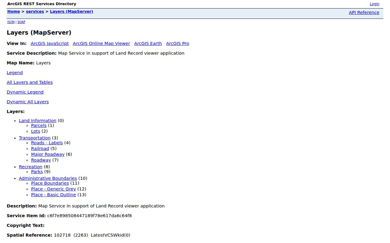
The layer page helps preserve how an adjacent-parcel observation was made. Save the query parameters, map layer, and access date with the result. A live service can change, and a polygon edge on a screen is not a legal survey boundary.
Validate Rockville Centre Neighbor Parcels
After GIS identifies the polygons, validate each one in Nassau LRV. Search by house number, street, Town, and ZIP, or use the SBL if already known. The address search advises users to omit directional prefixes and road-type suffixes from the street-name entry. Preserve the exact query, the returned Village/Town fields, and the roll year shown on the card.
LRV can show assessment, tax, description, sales, and district information. Its values are assessment data, not market appraisals, and a card can carry a distinct mailing address for tax correspondence. That address can point to an agent, business, another residence, or a post office box. It is not evidence of who occupies the parcel.
Rockville Centre Boundaries and Time
GIS adds place context that an address line cannot. Nassau’s inventory includes roads, railroads, parks, place boundaries, aerials, FEMA layers, and historic 1926 and 1950 layers. Check whether the target sits beside a rail corridor, park edge, major road, or boundary before describing the block. Use the measure tool only for an approximate map observation, with units and date recorded.
Rockville Centre’s railroad arrived in 1867. Downtown tracks were at ground level by 1925, and later elevation with parking fields altered nearby reference points. Comparing a current parcel with the older GIS layers can explain changes in roads and lots without claiming that a historic map names a current household.
Rockville Centre Community Lists Not Found
The reviewed official sources did not provide a comprehensive inventory of private Rockville Centre neighborhood associations, block groups, or association rosters. That absence should be stated plainly. The Village, library, Historical Society, parks, road, railroad, and place-boundary layers are safer civic anchors than an informal neighborhood label. A current group should be verified directly from its own official organization page before being added to a local reference.
| Community source reviewed | What the source supports | Roster status |
|---|---|---|
| RVC Village government | Municipal departments and jurisdiction | No private block-association inventory located |
| RVC Public Library Archives | Historic newspapers, directories, maps, interviews, and local reports | Not a current community membership roster |
| RVC Historical Society | House histories, maps, subdivision plans, and local themes | Collection material, not a current neighbor directory |
| Rockville Centre Chamber | Local business and organization context | Business membership, not household membership |
That transparent gap matters. A map label, business member listing, or house-history article cannot be converted into a block roster. Use them for location history or organization context only.
Rockville Centre Neighbor Source Limits
Official and commercial categories serve very different purposes. The state voter lookup requires a known last name, first name, date of birth, county, and address. Its result is controlled by voter-registration rules, and the voter-file FOIL route requires an election purpose under Election Law §3-103(5). It is not a tool for building a block contact list. Commercial lookup categories may merge public and uncertain information, but they do not replace a dated county record.
| Source category | Useful for | Limit for a neighbor question |
|---|---|---|
| Official GIS and LRV | Parcel identity, map context, SBL, and roll-year information | Does not identify a current household or social relationship |
| Official Clerk instruments | Recorded land parties, dates, and legal descriptions | Recorded party is not necessarily an occupant |
| Official voter process | Authorized individual registration inquiry or election administration | Required credentials, privacy protection, and election-purpose rules apply |
| Commercial lookup category | Possible lead that requires independent verification | May be inaccurate, incomplete, stale, or inconsistent with official access limits |
When the purpose is a location question, return to the official map, LRV card, Clerk index, or dated library item. That creates a reviewable evidence trail instead of a compiled profile.
Trace Rockville Centre Neighbor History
Historic neighbors require a different chain from current map adjacency. Start with a dated map or directory, identify the lot or address nearby, then look for a Clerk map or deed index entry. A newspaper or Historical Society house history may corroborate a structure or subdivision event. The relevant dates should remain visible: a 1906 map, a 1938 directory, a 1977 subdivision record, and a current parcel card are four separate observations.
NY Heritage’s 1906 Rockville Centre maps use row and column sheet identifiers, including labels such as L_1_A. The maps can be matched to current SBL research through visible street, lot, and landmark detail. If only a directory exists, say that a name was listed nearby in that edition. If only a map exists, describe the lots and boundaries, not a household.
Privacy Limits for Rockville Centre Neighbors
New York public-record access does not erase privacy protections. The Address Confidentiality Program uses substitute mailing addresses for eligible participants, while confidential voter registration keeps qualifying records separate. A missing search response may reflect a safety safeguard, not an absence from Rockville Centre. Never use a public mailing address to infer a protected residence.
Do not collect or publish exact unit numbers, personal phone or email details, dates of birth, government identifiers, protected addresses, minor information, victim or witness details, or library-use records. RVC’s FOIL process can redact personal or safety-sensitive material, and a narrow request for a specific existing record is more appropriate than an open-ended request about people on a block.
Lawful use. Use parcel and historic-address records for limited, lawful purposes such as property history, family research, civic context, or avoiding a scam. Do not use them to stalk, harass, threaten, surveil, or contact another person without a lawful reason.